Canada Tourism | Canada Tourist Attractions
About Canada:

The land that is now Canada has been inhabited for millennia by various Aboriginal peoples. Beginning in the late 15th century, British and French expeditions explored, and later settled, along the region's Atlantic coast. France ceded nearly all of its colonies in North America in 1763 after the Seven Years' War. In 1867, with the union of three British North American colonies through Confederation, Canada was formed as a federal dominion of four provinces. This began an accretion of provinces and territories and a process of increasing autonomy from the United Kingdom. This widening autonomy was highlighted by the Balfour Declaration of 1926 and reaffirmed by the Statute of Westminster of 1931, which declared self-governing dominions within the British Empire to be equal. The Canada Act of 1982 finally severed the vestiges of legal dependence on the British Parliament.

Geography of Canada:

The country lies between latitudes 41° and 84°N, and longitudes 52° and 141°W. Since 1925, Canada has claimed the portion of the Arctic between 60° and 141°W longitude,but this claim is not universally recognized. Canada is home to the world's northernmost settlement, Canadian Forces Station Alert, on the northern tip of Ellesmere Island – latitude 82.5°N – which lies 817 kilometres (508 mi) from the North Pole. Much of the Canadian Arctic is covered by ice and permafrost. Canada has the longest coastline in the world, with a total length of 202,080 kilometres (125,570 mi); additionally, its border with the United States is the world's longest land border, stretching over 8,890 kilometres (5,520 mi).


Average winter and summer high temperatures across Canada vary from region to region. Winters can be harsh in many parts of the country, particularly in the interior and Prairie provinces, which experience a continental climate, where daily average temperatures are near -15 °C (5 °F), but can drop below -40 °C (-40 °F) with severe wind chills. In noncoastal regions, snow can cover the ground for almost six months of the year, while in parts of the north snow can persist year-round. Coastal British Columbia has a temperate climate, with a mild and rainy winter. On the east and west coasts, average high temperatures are generally in the low 20s °C (70s °F), while between the coasts, the average summer high temperature ranges from 25 to 30 °C (77 to 86 °F), with temperatures in some interior locations occasionally exceeding 40 °C (104 °F).
Canada Weather:
Canada Tourist Attractions:
Toronto:

With over 2.6 million residents, it is the fifth most populous city in North America. Its metropolitan area has over 5.5 million residents. Toronto is at the heart of the Greater Toronto Area (GTA), and is part of a densely populated region in Southern Ontario known as the Golden Horseshoe, which has a population of nearly 9 million people as of 2011. The census metropolitan area (CMA) had a population of 5,583,064, and the Greater Toronto Area had a population of 6,054,191 in the 2011 Census. Its cosmopolitan and international population reflects its role as an important destination for immigrants to Canada. Toronto is one of the world's most diverse cities by percentage of non-native-born residents, with about 49% of the population born outside Canada. Toronto is also consistently rated as one of the world's most livable cities by the Economist Intelligence Unit and the Mercer Quality of Living Survey.

CN Tower:

Its name "CN" originally referred to Canadian National, the railway company that built the tower. Following the railway's decision to divest non-core freight railway assets, prior to the company's privatization in 1995, it transferred the tower to the Canada Lands Company, a federal Crown corporation responsible for real estate development. Since the name CN Tower became common in daily usage, the abbreviation was eventually expanded to Canadian National Tower or Canada's National Tower. However, neither of these names is commonly used.
In 1995, the CN Tower was declared one of the modern Seven Wonders of the World by the American Society of Civil Engineers. It also belongs to the World Federation of Great Towers, where it holds second-place ranking.
Toronto City Hall:

In 1958, an international architectural competition was launched by Mayor Nathan Phillips in order to find a design for the New City Hall. This competition was won by Finnish architect Viljo Revell whose winning proposal came first amongst submissions from forty-two countries. Revell’s design consists of twin towers surrounding a white disk-like council chamber which is mounted on a raised platform, with entrances located below that are open to the public. There is also a ramp from the square that connects to the podium green roof and also leads to the council chamber. The two towers are of unequal height as the east tower is taller than the west. The City Hall is nicknamed “The Eye of the Government” because it resembles a large eye in a plan view. Revell died a year before the New City Hall was completed.
Yonge-Dundas Square:

Surrounding the square are other major landmarks, including the Toronto Eaton Centre, 10 Dundas Street East, 33 Dundas Street East, Ryerson University, Ed Mirvish Theatre, Atrium on Bay and Canada's largest media tower. The intersection is served by the Yonge-University-Spadina line of the Toronto Subway via Dundas station, connected to the PATH, and contains the city's first pedestrian scramble. The square is continuously illuminated by several corporate and brand-name logos in neon and electric signs and large liquid-crystal display (LCD) and light-emitting diode (LED) screens, which often display advertisements. Because of this, critics have referred to the square as "Toronto's Times Square".
Toronto Islands:

The islands comprise the largest urban car-free community in North America, though some service vehicles are permitted. Recreational bicyclists are accommodated on the ferries, and bicycles, quadracycles, and canoes can be rented on the islands as well.

St. Michael's Cathedral:
St. Michael's Cathedral is the Roman Catholic cathedral of the Roman Catholic Archdiocese of Toronto, Canada, and one of the oldest churches in the city. It is located at 200 Church Street in Toronto's Garden District. St. Michael's was designed by William Thomas, designer of eight other churches in the city, and was primarily financed by Irish immigrants who resided in the area. The Cathedral has a capacity of 1600.
Cathedral Church of St. James:

The church is listed as an heritage building under the Ontario Heritage Act and is the episcopal seat of the Anglican Church of Canada's Diocese of Toronto.
Royal St. George's College, on Howland Avenue, is the church's choir school and is open to boys in grades 3 through 12.

Casa Loma:
Casa Loma (Spanish for Hill House) is a Gothic Revival style house and gardens in midtown Toronto, Ontario, Canada, that is now a museum and landmark. It was originally a residence for financier Sir Henry Mill Pellatt. Casa Loma was constructed over a three-year period from 1911–1914. The architect of the mansion was E. J. Lennox, who was responsible for the designs of several other city landmarks.
Toronto Eaton Centre:
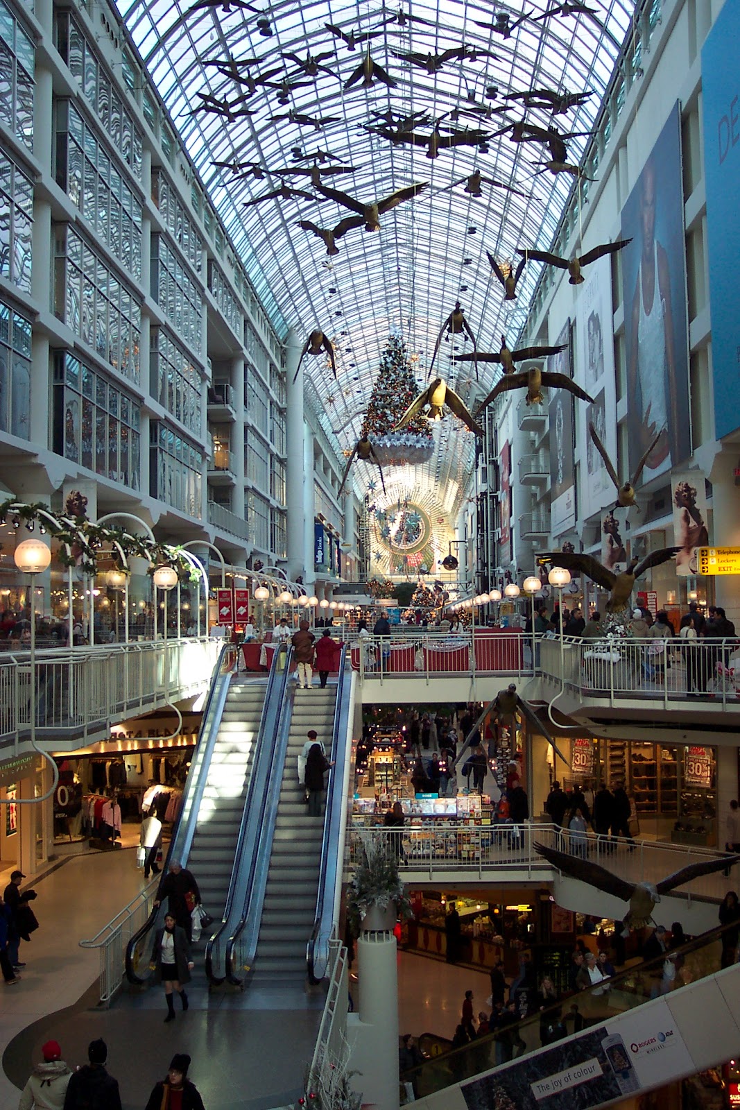
The Eaton Centre is bounded by Yonge Street on the east, Queen Street West on the south, Dundas Street West on the north, and to the west by James Street and Trinity Square. Its interior passages also form part of Toronto's PATH underground pedestrian network, and the centre is served by two Toronto subway stations: Dundas and Queen. The complex also contains three office buildings (at 20 Queen Street West, 250 Yonge Street and 1 Dundas Street West) and the Ryerson University Ted Rogers School of Management. Additionally, the Eaton Centre is linked to a 17-storey Marriott hotel, and to Canada's largest store, the flagship location of The Bay department store chain.
Royal Ontario Museum:

Founded in 1912, the museum has maintained close relations with the University of Toronto throughout its history, often sharing expertise and resources. The museum was originally under the direct control and management of the University of Toronto, until 1968, when it became an independent institution. Today, the museum is Canada's largest field-research institution, with research and conservation activities that span the globe.
With more than six million items and forty galleries, the museum's diverse collections of world culture and natural history are part of the reason for its international reputation. The museum contains notable collections of dinosaurs, minerals and meteorites, Near Eastern and African art, East Asian art, European history, and Canadian history. It also houses the world's largest collection of fossils from the Burgess Shale with more than 150,000 specimens. The museum even contains an extensive collection of design and fine arts. These include clothing, interior, and product design, especially Art Deco.
Queen's Park:

The park is nearly an enclave of the University of Toronto, which occupies most of the surrounding lands. The park itself is technically owned by the University of Toronto, but the property was leased to the Government of Ontario in 1859 for a period of 999 years, set to expire in 2858. Ministry buildings of the Ontario government occupy other properties to the east of the park, in an area between Wellesley Street and Grosvenor Street. While not directly adjacent to the park, the Royal Ontario Museum and the Gardiner Museum are both located nearby.
Toronto Zoo:

Encompassing 287 hectares (710 acres), the Toronto Zoo is the largest zoo in Canada. It is divided into seven zoogeographic regions: Indo-Malaya, Africa, Americas, Tundra Trek, Australasia, Eurasia and the Canadian Domain. Some animals are displayed indoors in tropical pavilions and outdoors in what would be their naturalistic environments, with viewing at many levels. It also has areas such as the Kids Zoo, Waterside Theatre and Splash Island. The zoo is currently home to over 16,000 animals (including invertebrates and fish) representing over 491 species.
Niagara Falls:

MarineLand:

The park slogan for many years has been "Everyone Loves Marineland". An earlier slogan was "Happiness is Marineland." During the summer months they ran commercials in Ontario, Quebec, Pennsylvania, and Upstate New York television stations (at least as far east as the Burlington, Vermont media market) featuring a jingle that highlights the features of the park, with new verses added for new attractions every year.[6] The park's mascot is known as King Waldorf, a walrus dressed like a king. The park also runs a campground named after him. Some versions of the jingle have been sung by Suzie McNeil and Marco Di Felice.
Fallsview Indoor Waterpark:

Montreal:

As of May 10th 2011, Statistics Canada identifies Montreal's Census Metropolitan Area (CMA) (land area 4,259 square kilometres (1,644 sq mi)) as Canada's second most populous with an estimated metropolitan area population of 3,824,221 and a population of 1,886,481 in the "agglomeration" of Montreal, which includes all of the municipalities on the island of Montreal. The city of Montreal proper had a population of 1,649,519.

In 2010, Montreal was named a hub city, ranked 34th globally out of 289 cities for innovation across multiple sectors of the urban economy, in the Innovation Cities Index by 2thinknow. Montreal was the next Canadian city in the annual index behind nexus city Toronto in 12th place and ahead of fellow hub cities Calgary, Quebec City, Vancouver and Edmonton. In 2009, Montreal was named North America's number one host city for international association events, according to the 2009 preliminary rankings of the International Congress and Convention Association (ICCA).
Vancouver:
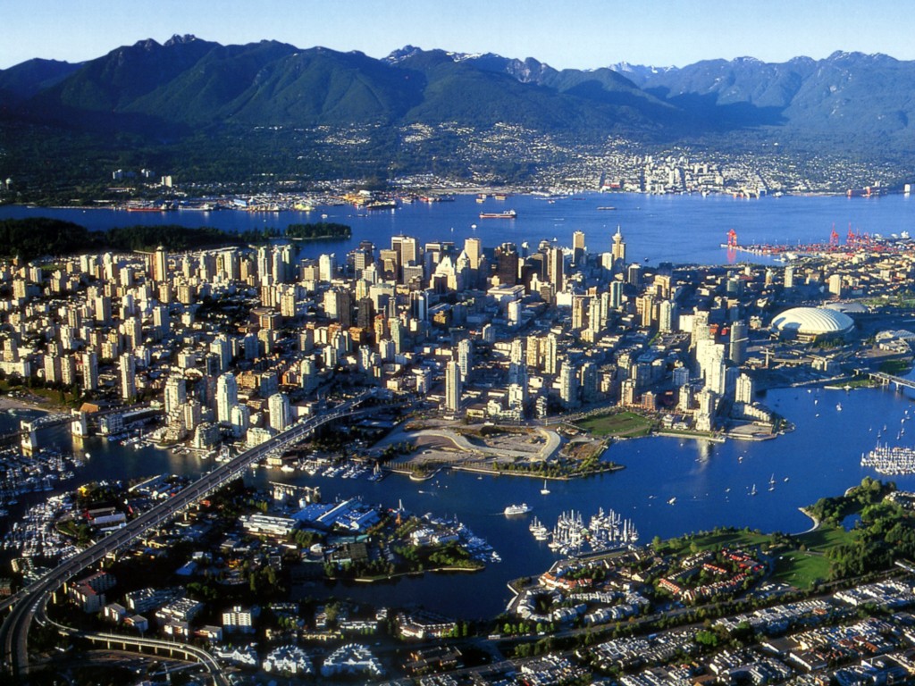
The original settlement, named Gastown, grew around the Hastings Mill logging sawmill and a nearby tavern, both established in 1867. Enlarging to become the townsite of Granville, with the announcement that the railhead would reach the site it was renamed "Vancouver" and incorporated as a city in 1886. By 1887, the transcontinental railway was extended to the city to take advantage of its large natural seaport, which soon became a vital link in a trade route between the Orient, Eastern Canada, and London. As of 2009, Port Metro Vancouver is the busiest and largest port in Canada, and the most diversified port in North America. While forestry remains its largest industry, Vancouver is well known as an urban centre surrounded by nature, making tourism its second-largest industry. Major film production studios in Vancouver and Burnaby have turned Metro Vancouver into the third-largest film production centre in North America after Los Angeles and New York City, earning it the film industry nickname, Hollywood North.


Capilano Suspension Bridge:
The Capilano Suspension Bridge is a simple suspension bridge crossing the Capilano River in the District of North Vancouver, British Columbia, Canada. The current bridge is 136 metres (446 ft) long and 70 metres (230 ft) above the river. It is part of a private facility, with an admission fee, and draws over 800,000 visitors a year.
Granville Island:
Granville Island is a peninsula and shopping district in Vancouver, British Columbia, Canada. It is located in False Creek directly across from Downtown Vancouver's peninsula, under the south end of the Granville Street Bridge.
The peninsula was once an industrial manufacturing area, but today it is now a major tourist destination and working neighbourhood. In 2004, Project for Public Spaces named Granville Island "One of the World's Great Places".
Chinatown:

Chinatown remains a popular tourist attraction, and is one of the largest historic Chinatowns in North America. However, it went into decline as newer members of Vancouver's Cantonese Chinese community dispersed to other areas of the metropolis. It has been more recently overshadowed by the newer Chinese immigrant business district along No. 3 Road in the Vancouver suburb of Richmond, which had been an Anglo-Saxon bastion until the 1980s. Many affluent Hong Kong and Taiwanese immigrants have moved there since the late 1980s, coinciding with the increase of Chinese-ethnic retail and restaurants in that area. This new area is designated the "Golden Village" by the City of Richmond, which met resistance to the proposed renaming of the area to "Chinatown" both from merchants in Vancouver's Chinatown and also from non-Chinese residents and merchants in Richmond itself.
Stanley Park:

It is more than 10% larger than New York City's Central Park and almost half the size of London's Richmond Park. The park attracts an estimated eight million visitors every year, including locals and tourists, who come for its recreational facilities and its natural attributes. A paved 8.8 kilometres (5.5 mi) seawall path circles the park, which is used by 2.5 million pedestrians, cyclists, and inline skaters every year. Much of the park remains forested with an estimated half million trees, some of which stand as tall as 76 metres (249 ft) and are up to hundreds of years old. There are approximately 200 kilometres (120 mi) of trails and roads in the park, which are patrolled by the Vancouver Police Department's equine mounted squad. The Project for Public Spaces has ranked Stanley Park as the sixteenth best park in the world and sixth best in North America.

Butchart Gardens:
The Butchart Gardens is a group of floral display gardens in Brentwood Bay, British Columbia, Canada, located near Victoria on Vancouver Island. The gardens receive more than a million visitors each year. The gardens have been designated a National Historic Site of Canada due to their international renown.
Ottawa:

Founded in 1826 as Bytown and incorporated as "Ottawa" in 1855, the city has evolved into a political and technological centre of Canada. Its original boundaries were expanded through numerous minor annexations and ultimately replaced by a new city incorporation and major amalgamation in 2001 which significantly increased its land area. The name "Ottawa" is derived from the Algonquin word adawe,meaning "to trade". Initially an Irish and French Christian settlement,Ottawa has become a multicultural city with a diverse population.
The 2011 census had the city's population as 883,391, and the metropolitan population as 1,236,324. Mercer ranks Ottawa with the second highest quality of living of any large city in the Americas, and 14th highest in the world. It is also rated the second cleanest city in Canada, and third cleanest city in the world. In 2012, the city was ranked for the third consecutive year as the best community in Canada to live in by MoneySense.
Parliament Hill:

Originally the site of a military base in the 18th and early 19th centuries, development of the site into a governmental precinct began in 1859, after Bytown was chosen by Queen Victoria as the capital of the Province of Canada. Following a number of extensions to the parliament and departmental buildings and a fire in 1916 that destroyed the Centre Block, Parliament Hill took on its present form with the completion of the Peace Tower in 1927. Since 2002, an extensive $1 billion renovation and rehabilitation project has been underway throughout all of the precinct's buildings; work is not expected to be complete until after 2020.
Canadian Rockies:

The Canadian Rockies have numerous high peaks and ranges, such as Mount Robson (3,954 metres (12,972 ft)) and Mount Columbia (3,747 metres (12,293 ft)). The Canadian Rockies are composed of shale and limestone. Much of the range is protected by parks and a World Heritage Site.
Bow River:

The river is an important source of water for irrigation and drinking water. Between the years 1910 and 1960, the Bow River and its tributaries were engineered to provide hydroelectric power, primarily for Calgary's use. This significantly altered the river's flow and certain ecosystems.
Banff National Park:

The Canadian Pacific Railway was instrumental in Banff's early years, building the Banff Springs Hotel and Chateau Lake Louise, and attracting tourists through extensive advertising. In the early 20th century, roads were built in Banff, at times by war internees, and through Great Depression-era public works projects. Since the 1960s, park accommodations have been open all year, with annual tourism visits to Banff increasing to over 5 million in the 1990s. Millions more pass through the park on the Trans-Canada Highway. As Banff is one of the world's most visited national parks, the health of its ecosystem has been threatened. In the mid-1990s, Parks Canada responded by initiating a two-year study, which resulted in management recommendations, and new policies that aim to preserve ecological integrity.
Jasper National Park:

Waterton Lakes National Park:

Operated by Parks Canada, Waterton is open all year, but the main tourist season is during July and August. The only commercial facilities available within the park are located at the Waterton Park townsite. The park ranges in elevation from 1,290 metres (4,232 ft) at the townsite to 2,910 m (9,547 ft) at Mount Blakiston. It offers many scenic trails, including Crypt Lake trail. In 2004, Waterton Lakes National Park had 367,500 visitors.
Aurora:

Nahanni National Park Reserve:

Yoho National Park:

Yoho covers 1,313 km² (507 mi²) and it is the smallest of the four contiguous national parks (NP). Yoho, together with Jasper NP, Kootenay NP and Banff NP, along with three British Columbia provincial parks—Hamber Provincial Park, Mount Assiniboine Provincial Park, and Mount Robson Provincial Park—form the Canadian Rocky Mountain Parks World Heritage Site. The park's administrative and visitor centre are located in the town of Field, British Columbia, beside the Trans-Canada Highway.
Hotels in Canada:
5 Star Hotels in Canada:
Four Seasons Hotel Toronto

The Hazelton Hotel
Windsor Arms Hotel
Sterling Inn & Spa
Sheraton on the Falls
Marriott Gateway on the Falls
Hotel Le St-James
Ritz-Carlton Montreal
Rosewood Hotel Georgia
Fairmont Pacific Rim
Prince of Wales
The Westin Ottawa
Minto Suite Hotel
ARC The Hotel
Ottawa Marriott Hotel
Brookstreet Hotel
Auberge Saint-Antoine
Budget Hotels in Canada:
Wellesley Manor

Hotel Eureka
Hotel Villa
Le Saint Malo
Econo Lodge Downtown
Quality Inn Downtown
Arkona Motel
Knights Inn Flamingo
Niagara Inn Downtown
President Motor Inn
Surfside Inn
Value Inn
Comfort Inn Downtown
Traveller's Haven Motel
Super 8
Howard Johnson Plaza Hotel
2400 Motel Ltd.
Canada Maps:


Canada Pictures:


